
The Caumsett Foundation
Dedicated to the conservation of
Caumsett State Historic Park Preserve

The parkway which was never built.
by Eastern Roads (www.nycroads.com)
When the Bethpage State Parkway opened in 1936, LISPC commissioner Robert Moses was considering extensions of the parkway south to Merrick Road in Massapequa, and north to the Northern State Parkway in Plainview. In the late 1950's and early 1960's, state and county officials further refined both extension proposals.
Unlike the earlier proposed extensions, the revised extensions were to be constructed as four-lane, dual-carriageway facilities. In addition, the existing Bethpage State Parkway was to be upgraded as a modern parkway facility.
The extensions were to be built as follows:
SOUTHERN EXTENSION: Beginning at the Southern State Parkway, the Bethpage State Parkway was to have been extended two miles south through Massapequa to Merrick Road (Nassau CR 27A) in Massapequa. The right-of-way for the parkway was to have been through Massapequa State Park, so additional land acquisition was not an issue for Moses.
Interchanges were to have been built at the following locations:
-
•EXITS B-X E/W: Nassau CR 27A (Merrick Road) - "trumpet" interchange
-
•EXITS B-X E/W: NY 27 (Sunrise Highway) - full "cloverleaf" interchange
-
•EXITS B1 E/W: Southern State Parkway - reconstructed as full "cloverleaf" interchange
NORTHERN EXTENSION: Beginning at the existing terminus at Bethpage State Park, the Bethpage State Parkway was to have been extended 11 miles north through Bethpage, Plainview, Woodbury, Cold Spring Harbor and Lloyd Harbor. North of the Northern State Parkway, the Bethpage State Parkway was to be designated as the Caumsett State Parkway.
Interchanges were to have been built at the following locations:
-
•EXITS B1 E/W: Southern State Parkway - reconstructed as full "cloverleaf" interchange
-
•EXIT B2: Nassau CR 97 (Boundary Avenue) - reconstructed as "diamond" interchange
-
•EXIT B3: NY 24 (Hempstead Turnpike) - reconstructed as "diamond" interchange
-
•EXIT B4: Nassau CR 186 (Central Avenue) - partial "cloverleaf" interchange
-
•EXIT B5: NY 135 (Seaford-Oyster Bay Expressway) - "scissors" interchange allowing northbound-to-northbound and southbound-to-southbound movements only; existing traffic circle (shown as EXIT B5 on maps) was to have been eliminated
-
•EXIT B6: Plainview Road-Broadway - "diamond" interchange; was to have included new entrance to Bethpage State Park
-
•EXIT B7: Nassau CR 25 (Old Country Road) - full "cloverleaf" interchange
-
•EXITS B8 E/W: I-495 (Long Island Expressway) - partial "cloverleaf" interchange (movements Bethpage Parkway N/B to I-495 E/B and W/B, I-495 W/B to Bethpage Parkway S/B, I-495 E/B to Bethpage Parkway S/B); right-of-way set aside for full "cloverleaf" upgrade)
-
•EXITS B9 (C1) E/W: Northern State Parkway - full "cloverleaf" interchange
-
•EXIT B10 (C2): NY 25 (Jericho Turnpike) - "diamond" interchange
-
•EXIT B11 (C3): NY 25A (Main Street) and NY 108 (Harbor Road) - interchange configuration unknown
-
•END PARKWAY: Caumsett State Park
At the northern terminus of the Caumsett State Parkway, there was to be a new 1,500-acre Caumsett State Park on the site of the former Marshall Field estate in Lloyd Harbor. The new park on Long Island Sound, with its proposed beach, boardwalk, bathhouse, picnic area, ball fields, and two golf courses, was envisioned as an "active use" park similar in nature to Sunken Meadow State Park.
EXTENSION PLANS THWARTED: Beginning in the early 1960's, Moses purchased rights-of-way for the northern extension. Residents in the wealthy enclaves of Lloyd Harbor and Cold Spring Harbor thwarted plans for both the "active use" state park and the parkway, though both remained on official plans through the 1960's and 1970's. However, without a state park as a destination, and with most of the north-south traffic needs in the area being met by the nearby Seaford-Oyster Bay Expressway (NY 135), the Bethpage State Parkway extension was not a high priority. Finally, in 1977, with Moses gone from the LISPC commissioner's post for more than a decade, Caumsett State Park opened as a "passive use" facility for hiking, biking and horseback riding.
In 1990, the Long Island Regional Planning Board resurrected plans for extending the Bethpage State Parkway to NY 25A in Cold Spring Harbor as part of its 20-year highway improvement program. The plan did not cite potential sources for funding the extension. By 1994, this proposal appeared to be dead. Prior to the Long Island Expressway HOV project in eastern Nassau, plans submitted to the state and county by Vollmer Associates suggested that the new service roads not have any overpasses (and were eventually built without them), and no provisions were made for a future parkway at the LIE.
A decade later, the NYSDOT proposed a short extension of the Bethpage State Parkway north to the Seaford-Oyster Bay Expressway (NY 135) as part of the "LITP 2000" long-range plan. The proposed extension, which would be constructed through the southwest corner of Bethpage State Park, awaits environmental study and public review.
In 2002, the NYSDOT handed over the Bethpage-Caumsett right-of-way from Bethpage State Park north to NY 25A to the New York State Office of Parks, Recreation and Historic Preservation (NYSOPRHP). The 7.4-mile-long, 400-acre linear park was re-established as Trail View State Park, and has multi-use trails for hiking, cycling and other activities.
THE BETHPAGE BICYCLE PATH: During the past 25 years, the NYSDOT converted the right-of-way for the Bethpage State Parkway south of the Southern State Parkway for the Bethpage Bicycle Path. The state now plans to extend this 13-foot-wide bicycle path north to the Syosset LIRR station. Once the $3.8 million project is completed later this decade, the bicycle path would extend for 16 miles.
The proposed bicycle path extension north from the present terminus at Bethpage State Park would utilize the Bethpage State Parkway right-of-way north through Old Bethpage and Plainview, crossing underneath the Long Island Expressway and the Northern State Parkway through new tunnels. It would veer west along Sunnyside Boulevard to Woodbury Road, and continue north along the Seaford-Oyster Bay Expressway right-of-way to Convent Road in Syosset.
The original plan called for the path to parallel the current Greenbelt Trail from Bethpage State Park along the Bethpage State Parkway-Caumsett State Parkway right-of-way north to NY 25A in Cold Spring Harbor. However, this plan was shelved due to fears that the bicycle trail would infringe upon the greenbelt.
-
 The History of the Caumsett Parkway


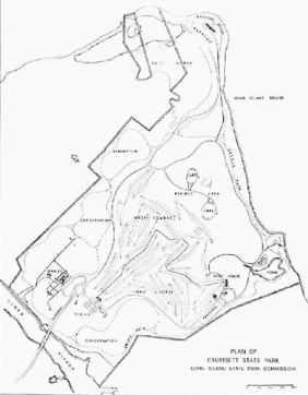
This 1961 map shows the proposed layout of Caumsett State Park with the northwest direction at the top of the map. Note how the proposed Caumsett State Parkway was to enter the park from the lower left-hand corner of the map, ending at a traffic circle.